Файл:Sevastopol, Ukraine.jpg

Повна роздільність (1080 × 1440 пікселів, розмір файлу: 455 КБ, MIME-тип: image/jpeg)
Опис файлу
| Опис |
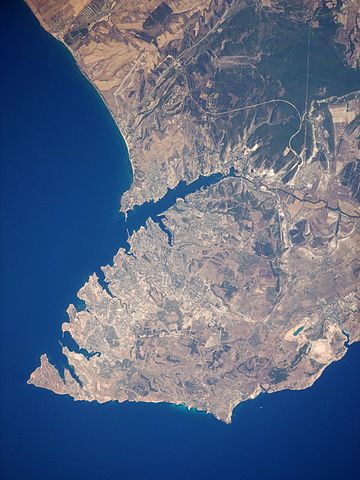
English: This satellite image highlights the jagged coastline of the southern Crimean Peninsula and the various docking areas of Sevastopol. The urban area is light grey, and it is bounded to the north and west by the Black Sea, to the south by vegetated (light green) and fallow (tan) agricultural fields, and to the east by the city of Inkerman and vegetated uplands (deep green). The city of Balaklava, to the south, houses another relic of the Cold War—an underground Soviet submarine base that is now open to the public as a monument. The Chernaya River issues into the Black Sea near Inkerman, flowing into the Sevastopol Inlet to the west.
|
||||||||||||||||||||||||||||||||||||||||||||||||||||||
| Час створення | |||||||||||||||||||||||||||||||||||||||||||||||||||||||
| Джерело | NASA Earth Observatory | ||||||||||||||||||||||||||||||||||||||||||||||||||||||
| Автор | This image was taken by the Nasa Expedition 20 crew. | ||||||||||||||||||||||||||||||||||||||||||||||||||||||
Image acquired with a Nikon D3 digital camera fitted with a 400 mm lens, and is provided by the ISS Crew Earth Observations experiment and Image Science & Analysis Laboratory, Johnson Space Centre. Instrument: ISS - Digital Camera.
Ліцензування
| Цей файл перебуває у суспільному надбанні, оскільки він був створений NASA (Національним управлінням з аеронавтики і дослідження космічного простору). Згідно з політикою NASA стосовно авторського права, «матеріали NASA не захищаються авторським правом, якщо не вказано протилежне». (Див. Template:PD-USGov, сторінку політики NASA стосовно авторського права, або політику використання зображень JPL.) | ||
 |
Попередження:
|
| Анотації | Це зображення має анотації: Переглянути анотації на Вікісховищі |
Історія файлу
Клацніть на дату/час, щоб переглянути, як тоді виглядав файл.
| Дата/час | Мініатюра | Розмір об'єкта | Користувач | Коментар | |
|---|---|---|---|---|---|
| поточний | 14:44, 20 січня 2015 | | 1080 × 1440 (455 КБ) | Anonimski | Rotated to proper map orientation |
| 12:27, 24 серпня 2009 |  | 1440 × 1080 (532 КБ) | Originalwana | {{Information |Description={{en|1=This astronaut photograph highlights the jagged coastline of the southern Crimean Peninsula and the various docking areas of Sevastopol. The urban area is light grey, and it is bounded to the north and west by the Black S |
Використання файлу
Така сторінка використовує цей файл:
Глобальне використання файлу
Цей файл використовують такі інші вікі:
- Використання в af.wikipedia.org
- Використання в ast.wikipedia.org
- Використання в azb.wikipedia.org
- Використання в az.wikipedia.org
- Використання в bn.wikipedia.org
- Використання в ca.wikipedia.org
- Використання в de.wikipedia.org
- Використання в de.wikivoyage.org
- Використання в en.wikipedia.org
- Використання в es.wikipedia.org
- Використання в fa.wikipedia.org
- Використання в is.wikipedia.org
- Використання в it.wikipedia.org
- Використання в mn.wikipedia.org
- Використання в pl.wikipedia.org
- Використання в pl.wiktionary.org
- Використання в ru.wikipedia.org
- Використання в uk.wikipedia.org
- Використання в www.wikidata.org
- Використання в zh.wikipedia.org